Mid-Columbia River Shrub-Steppe and Riparian Restoration Areas
Summary
The Columbia Basin Irrigation Project (CBIP) supports a large agricultural industry in the otherwise unproductive Shrub-Steppe ecosystem in the Mid-Columbia basin. The CBIP can be considered a highly engineered, man-made watershed that efficiently uses water to support crop production. However, there is growing concern that wastewater flowing into the Columbia River contributes to the nitrate and phosphate load in the river leading to toxic algae blooms. Normally, wastewater is channelized and fed directly into the river. We propose and identify various sites along the river that can be modified or engineered to be natural filtration systems that can help protect the Columbia River water quality and preserve the cultural, economic, recreational, wildlife and fisheries benefits that clean water provides to our local economy.
We base this concept on the similar Wetland, Riparian, Shrub-Steppe (WRSS) ecosystems that are found along tributaries to the Columbia and identify in the appendix many potential areas along the Hanford Reach and Lake Wallula that could be protected, rehabilitated or restored into an essential wastewater treatment system for the CBIP. Further these sites can provide enhanced public recreation, provide wildlife habitat and migration corridors, provide wetlands for migratory fowl and enhance local fisheries. Finally, we suggest a few initial sites to demonstrate the concept, that have minimal land ownership or usage conflicts and would require minimal engineering requirements that would hinder CBIP operation.
Introduction
The summer of 2021 was marked by low flows in the Columbia River and very high temperatures up to 115°F. Meteorologists introduced us to the term “heat dome”. Toxic algae levels rose to levels never before seen in the Columbia, a few dogs died and more sickened, no human deaths or injuries were reported but the health of the water became a concern to local residents. This event concerned many local environmental scientists and in this author’s 35 years of living in the mid-Columbia such an event was a disturbing harbinger of future water quality issues. Community leaders have become concerned about how unhealthy water might negatively impact the economy of the area supported by fishing, boating and water recreation as well as life quality.
Eutrophication is the technical term for the abundance of nutrients required to induce toxic algae blooms. The two most typical eutrophicates are nitrates, and phosphates and are introduced to the river system by agriculture and residential uses of fertilizers. Farmers typically use fertilizers at rates that optimize crop profits and are a major cost factor in determining application rates. Urban residents are not confined by this profit motive but rather emphasize the esthetic aspect of lawns and gardens. They typically use fertilizers (as well as pesticides and herbicides) at greater per-acre rates than farmers because of the differing motives and objectives.
The CBIP provides efficient use of river water for irrigation of agricultural lands in Grant and Franklin Counties. It extends from Banks lake as the northern inlet and reaches as far south as the city of Pasco. The Franklin County Irrigation District (FCID) provides water to the residential areas of Pasco. While water is lost from the system through transpiration from crops and evaporation from open waterways, a very significant percentage percolates down through the vadose zone to the underlying water table. In the CBIP the water table has risen several hundred feet due to irrigation. Drainages like Crab Creek were dry prior to construction of the CBIP but now carry vast quantities of irrigation water. On the steeper banks of the Columbia, springs, fed by irrigation, can be found several hundred feet above the river level. The irrigation districts maintain several wasteways that carry excess water back into the Columbia River. Normally these wastewater channels empty directly into the Columbia River.
Together these waste water pathways carry a significant load of eutrophicates that can result in toxic algae growth. We propose the construction of ecological zones and identify candidate sites which would reduce and capture the eutrophicate load. The basic concept is to dechannelize the irrigation system near the channel entrance to the river, create new riparian zones and wetlands with the now dispersed water and restore adjacent shrub-steppe habitats. The concept is modeled after the naturally occurring Wetland, Riparian, Shrub-Steppe (WRSS) ecosystems that arise along natural tributaries of the Columbia River. We apply this concept to the heavily engineered irrigation system that supports the agricultural powerhouse of the mid-Columbia. In essence we have constructed a highly productive water distribution system but we forgot to put in a filtration system. We propose various sites to create these necessary filtration systems.
Each WRSS zone would be engineered to create a natural wastewater treatment system that completes the nitrification cycle and transforms the incoming nitrates and nitrites into nitrogen gas. The WRSS zones are designed to mimic the function of a municipal wastewater treatment plant but to do so with naturally occurring vegetation typical of this region. They might also be viewed as “constructed wetlands” but using naturally occurring flow paths rather than constructing dedicated piping systems. This approach provides, the region with many other benefits besides improving Columbia River water quality. Each area can support a diverse wildlife population ranging from fishery friendly insect populations, cover and forage for small mammals, larger browsing ungulate populations and top end predators such as eagles, osprey, coyotes and foxes. These areas can also be stopping points for migratory fowl. These zones can also be open to the non-motorized public and provide for improved hunting, fishing, birdwatching and hiking.
Wetland, Riparian, Shrub-Steppe (WRSS) Ecosystem
Many arid areas around the world receive sufficient rain to sustain a thin grass and shrub covering as well as adapted wildlife to create the classic Shrub-Steppe habitat. The flora and fauna adapt by taking advantage of wet and often cold seasons where water supports reproduction but go dormant to varying degrees during the dry and usually hot seasons. Permanent water sources are rare or non-existent and the water table may be many hundreds of feet below the surface. Wetlands may come and go with the seasons but are mostly short lived. The vadose zone rarely has a net flow of water down to the water table and any water accumulated near the surface is lost to the atmosphere through transpiration and evaporation during the dry season.
Through most of the Mid-Columbia Basin region, the Shrub-Steppe habitat is punctuated by river systems fed from nutrient rich regions in the surrounding mountains which do receive significant amounts of precipitation. The rivers support abundant flora and fauna and the Columbia and its tributaries were once known as a major Salmon fishery. The Columbia River has a number of tributaries that provide water from the Cascade Mountain Range such as the Yakima, Wenatchee and Methow Rivers. The Columbia also receives water from the Blue Mountains via the Walla Walla and Umatilla Rivers. A very large portion of water comes from watersheds in Idaho, Montana and Canada. But south of the Spokane River there are NO natural tributaries on the east side of the Columbia until one reaches the Snake River. It is in this region that the CBIP has created an artificial watershed but without the associated wetlands and riparian habitats that are associated with natural tributaries to the Columbia.
Between this nutrient-rich water source and the apparently barren Shrub-Steppe is the Riparian habitat. This region characteristically extends from only a few to many hundreds of feet inland from the main river. The width is determined primarily by the local geology. Here in the Columbia Basin, the shoreline is often composed of alluvial flows ranging in size of coarse stone, to gravel and fine sand or silt. These are highly porous, do not retain water and are often geologically unstable. It is only near the shoreline that riparian habitats form where the water table is near the surface. In regions where rock formations such as basalt appear at the surface, the riparian zone can literally be stepped over. In other regions fairly large wetlands may form, fed primarily by the river system.
A mature riparian zone can support large trees, small and medium size shrubs and many smaller plants. Plant size and water needs often grade from large and thirsty near the shore to small and hardy. Eventually as the land surface rises above the water table, the Shrub-Steppe habitat predominates. The riparian zone may also support wild life by providing forage, cover and nesting areas. These include abundant insect life, small mammals, birds, deer and other herbivories that feed off the local vegetation in addition to top-tier predators including coyotes, wolfs, bears and formerly humans. The predators will often migrate between the major riparian areas in search of food. Beaver may also be present and are critical to building water retaining structures that help expand the riparian zone. Bigger riparian areas are often rest or wintering stops for migratory birds.
The outward form of the WRSS belies a hidden bacterial and mycorrhizal ecosystem that is essential to the filtering function of created or artificial WRSS zones. We will not at this time do an in-depth description of the Nitrogen Cycle. However, nitrogen in irrigation wastewaters is primarily in the form of nitrates that can be assimilated and stored in the riparian habitat. These woody materials decay in contact with wetlands and near surface water tables to support anerobic conversion to nitrogen gas. This is a vast oversimplification of the process but provides the basic engineering goals of an artificial or man-made WRSS.
Existing Model Systems
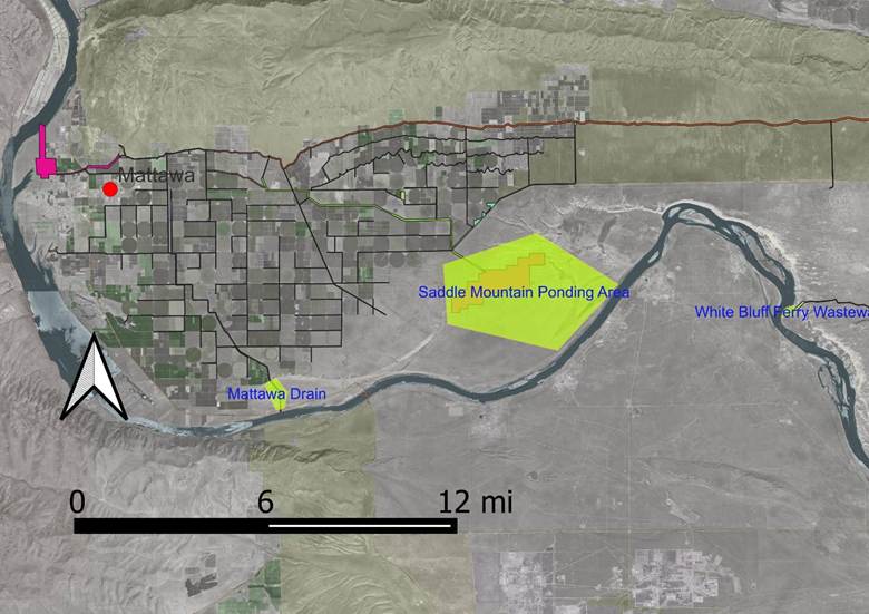
The Hanford Reach National Monument has two WRSS areas that provide a model for other proposed sites. These are the Saddle Mountain Ponding Area and the White Bluffs Ferry landing. Both these areas are fed by South Columbia Basin Irrigation District (SCBID) wasteways but, rather than channelizing the water directly into the Columbia, the wasteway is allowed to disperse and form small ponds or delta areas that provide water to a large area along the shoreline. Consequently, riparian zones form around the retained water that provide the benefits noted above. Eutrophication nutrients (nitrates and phosphates) are retained in the riparian zone and eventually spread outward to enhance the adjacent Shrub-Steppe habitat.
High Potential WRSS Areas
Below we provide a complete list of areas that have some native habitat function and which to varying degrees could be protected, rehabilitated or expanded to achieve some of the WRSS ecosystem function. Here we list a few areas that have minimal logistical barriers to creation of a WRSS ecosystem. The selection is based upon minimal ownership issues, lack of conflicting agricultural, residential or industrial use, minimal land acquisition costs and/or existing geological hazard.
Savage Island Wasteway – Part of the Hanford Reach National Monument, the wasteway could be dechannelized and redirected across the relatively flat zone below the bluffs
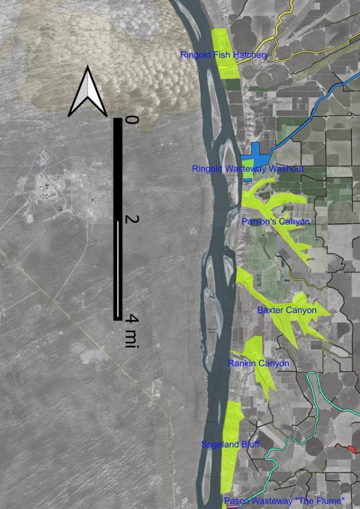
Ringold Springs – This relatively flat zone is a WDFW fish hatchery while the rivers edge is a popular recreation area. There is considerable unused ground over which the channelized wasteway can be redirected to create wetlands and riparian habitat. This would be a good demonstration site.
Ringold Wasteway – This is a geologically unstable area because of the wasteway and creation of a WRSS could prevent further sluffing and landslides.
Parson’s Canyon – This is one of the largest canyons in the area and cannot be used for agriculture or residential purposes without creating geologic instability. Parson’s Canyon and the adjacent Baxter Canyon could provide significant wildlife habitat and eventually become part of a wildlife corridor extending over to the Snake River. The existing riparian habitat could be improved by adding small wetlands or ponds and the existing poor shrub-steppe habitat restored.
Sageland Bluffs – As a highly geologically unstable area, there is potential for a massive landslide to block portions of the Columbia River and endanger the 300 area of the Hanford site. The hill side has many irrigation-fed springs that could provide sufficient water sources for stabilizing ground movement with riparian habitat.
Richland Bend Habitat Management Unit – Perhaps one of the largest wetlands/riparian/wildlife zones on the Franklin Co. side of the Columbia River, it may be endangered by commercial and residential development as the Broadmoor area expands toward the river.
Appendix A — Complete List of Potential Shoreline WRSS sites.
Mattawa Drain
The Mattawa Drain is a SCBID wasteway that is an open channel leading from the Mattawa irrigation region south to the Columbia River. There is a potential to un-channel this wasteway and create a riparian filter or ponding area. Adjacent to this channel is a large Shrub-Steppe (SS) area that does not appear to be farmed. However, the land does not appear to be healthy SS and may be a major restoration site. Currently, it has minimal industrial use and no farm use. Hence it might be a cost-effective purchase. In addition, it is near the Hanford Reach National Monument. This is in Grant County and ownership of this region is undetermined.
Saddle Mountain Ponding Area
This ponding area in the Hanford Reach National Monument (HRNM) if fed by the SCBID Saddle Mountain Wasteway. It appears to have been intentionally engineered to slow water flow and provide for some riparian habitat. It is mentioned here as a potentially positive example of what could be done with other wasteways which are currently being dumped directly into the Columbia. I need to find out who was responsible for implementing this idea. Rick Leaumont
White Bluffs Ferry Wasteway
WB10WW1 is a wasteway that drains SCIBID irrigation of farms east of the HRNM. It provides yet another example of how wasteways can be terminated in wetlands instead of being directly piped into the Columbia.
Savage Island Wasteway
SCBID WB5WW1 wasteway enters the Columbia along a small channel separating Savage Island from the left bank. It is possibly dry in low water. Maps show this area is part of the HRNM but may also be owed by Eden Mountain Mgt Co. per the Franklin Co. parcel number. It is currently an open channel and has considerable potential to be de-channeled to create a Wetland, Riparian, Shrub-Steppe (WRSS) zone.
Ringold Springs
The Ringold Springs area is a popular recreation site managed by the WDFW. It is also the Meseburg/Ringold fish hatchery also operated by the WDFW. The SCBID wasteway, PE16.4WW, enters about the middle of this complex and is completely channelized. There is considerable land to the north and south which could be converted to a WRSS zone without disturbing (and possibly enhance) the recreational or hatchery functions. The land is owned by the WDFW and Bureau of Reclamation (BR) and SCBID probably has easements for the wasteway channel. As the area of land in question is significant, the ownership is not private and has frequent public use, it is a ideal site to consider for a WRSS rehabilitation and demonstration project.
Ringold Wasteway
The Ringold Wasteway is different than the PE16.4WW wasteway at Ringold Spring. Rather it enters the Columbia River across from Homestead Island about 3 miles south of Ringold Springs. The Wasteway is channelized until a point where the ground collapsed and washed out. This washout occurred within the last 10 years but I was not able to find an exact date for the event. The stream has or was re-channelized through the washout area. This area could be a site for reconstruction/restoration while also providing ground stabilization. South of the wasteway, the land is owned by the BR, while the northern edge is owned by David R. Morgan who has a small orchard about ½ mile north. SCBID apparently has easement rights to a large portion of the washed-out area as well as the wasteway itself. The washout blocked a significant portion of the Columbia River channel between the left bank and Homestead Island. This site might also be a good demonstration project as the ownership is not complex and the need to stabilize the river bank is of benefit to area farmers. It is also a good example of why wasteways should not be channelized completely to the river’s edge.
Parson’s, Baxter and Rankin Canyons
Further south of Ringold lie three significant canyons whose geology and ecology are similar and hence we consider them as a group. All are steep ravines with a Shrub-Steppe habitat in poor condition and a riparian zone closely confined to the main drainage. The ground is too unstable and steep for agriculture but are clearly delineated by a sudden falling off from the relatively flat and heavily irrigated agriculture land. Baxter and Rankin canyons have sufficient flat ground at the canyon mouth to support agriculture. SCBID maps show wasteways in Baxter and Rankin canyons but it is not clear if these are buried pipes or open canals. SCBID maps show no wasteway in Parson’s canyon but all three carry significant amount of water to the river.
Of these three canyons, Parson’s probably provides the best site for creation of a WRSS. First it appears most of the water flow is on or near the surface and the canyon complex has 2-3 miles of stream bed and is approximately 1500 acres in size depending on how one draws the boundaries. The near river land is owned by either the BR or the USACE and Richard C & Ann S Conrad own a majority of the canyon bottom land upstream from the BR land.
Sageland Bluffs
This may have a more common name but I will use Sageland Bluffs for now. South of Rankin Canyon there are a few homes along N. Columbia River Drive for about 1 mile. From the last home and south past Carbody Beach to just north of the Pasco Wasteway (The Flume), the land is unstable and saturated with irrigation water. It has frequent springs that can be 100’s of feet above the river level, The ground is continually slumping and is unsuitable for either agriculture or residential use.
The USACE owns a narrow strip of land along the shore. There are then two parcels of land owned by LUNU LLC (Ray Law) (57 acres, $200,700 assessed value) and the Boy Scouts of America (44 acres, $160,800 assessed value) just adjacent to the USACE strip and the two extend almost the entire length of this region. Just below the actual bluff edge, the land is owned by GMP ORCHARDS LLC and CHIAWANA VISTA FARMS LLC and the Washington Department of Natural Resources. It is interesting that the WDNR has some ownership of this region and it suggest there may be some motive for land or habitat preservation. The BSA land is listed for sale at about 550,000 which is a very unreasonable number given the limited use of the land and the assessed value.
However, there is a possibility of a major landslide that could potentially divert the Columbia River and adversely impact the 300 area of the Hanford site. Also, given the risk of landslide and slumping to the farmers at the top of the bluff, there may be interest in stabilizing this land and creating a WRSS zone. From an engineering and ecological perspective, it is not clear how this might be achieved.
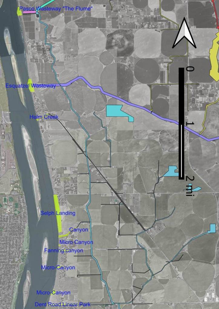
Pasco Wasteway or “The Flume”
This is a popular recreation area for both swimming and fishing. Ownership is by the USACE with easements for SCBIS. There is some riparian habitat adjacent to the canal but given the nearby roads and agriculture land it is difficult to see how the habitat of this area might be improved. The need here is for preservation of public access and habitat.
Esquatzel Wasteway
Know to SCBID as the Esquatzel Diversion Canal. This is also a popular recreation and fishing area. Land north of the canal is owned by the USACE while pieces south of the canal are owned by Franklin County and Patrick McDaniel (aka Green Energy LLC). Franklin Co. also owns 26 acres east of Columbia River Rd. and Sount of the Canal. That parcel appears to be used for gravel storage or mining and misc. junk.
The land ownership gives this site some potential to become a WPSS or even Franklin Countys first public park.
Micro-Canyon Reach
From the Esquatzel Wasteway to Burns Rd. the land rises creating a relatively short steep bank with many small short ravines that can carry surface water or have drainage pipe. These include Helm Creek, Fanning Rd., the Dent Rd. wasteway (PP5.9) as well as Selph Landing and the SCBID wasteway a couple of hundred yards south (PP4.3WW)
While there is much that could be done in this shoreline reach, it is now being heavily developed and property values are high. There is considerable need for public access to the river but these access points would be primarily for local neighborhood use. Local residents would probably not favor broader public access, parking areas or signage. Each of the micro ravines has potential for enhanced habitat and support for wildlife. Land ownership is problematic as even preservation minded residents may not favor public access but may be in favor of enhanced habitat and wildlife that adds value to their local environment and property.
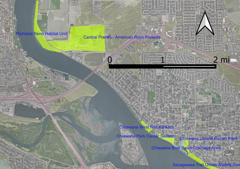
Richland Bend Habitat Management Unit (RBHMU)
The RBHMU extends from Burns road south along the shoreline and west of shoreline drive to the southern edge of the gravel pit. It is one of the largest contiguous natural wetland areas along the Franklin Co. side of the shoreline and the primary objective should be preservation of its wildlands character. It is a popular area for bird watching as well as hiking.
There are, unfortunately, plans that could endanger public access and habitat health. First the northern end of the unit abuts the dock and pumping plant that the Burns family owns. They have traditionally physically questioned and confronted anyone who access the USACE property near the dock and pumping station and consider public access to be trespassing. The legal propriety of this behavior is questionable. It is not clear that the Burns’ have an easement to access their dock or one that prohibits other public use of the land. The dock is probably in violation of construction standards and may be a public nuisance.
The City of Pasco has documented in their “Broadmoor Development Plan” that the RBHMU will become a public park. In addition, they plan to acquire the area from the USACE through “reconveyance” after which the USACE will have little say in its use or modification. However, the Pasco Shoreline Master Plan shows Subreach 1d which covers this area as a “natural” area.
This is defined in the SMP as “The purpose of the Natural shoreline designation is to protect those shoreline areas that are relatively free of human influence or that include intact or minimally degraded shoreline ecological functions less tolerant of human use. These systems require that only very low-intensity uses be allowed in order to maintain the ecological functions and ecosystem-wide processes. Consistent with the policies of the designation, restoration of degraded shorelines within this environment is appropriate and conversion to a more impactful use could require remediation at some other location.
In summary there are many legal issues regarding the status of this land and how best to protect its current habitat function.
In addition, the Broadmoor Plan currently suggests expanding Shoreline drive to a major arterial (probably 4 lanes) and changing the zoning on the east side of the road to mixed commercial and residential. This would dramatically increase undesired public use of the land and potentially result in severe degradation of the habitat.
One potential solution is to create a buffer zone on the east side of shoreline drive by moving shoreline drive inland, converting the old road to a bicycle path and converting some of the property on the east side to public park. The city is currently considering this idea amongst others in a revision of the Pasco Parks and Recreation Plan.
The land east of shoreline drive is owned by Horrigan Farms Inc., and Chubby Cherries LLC. The latter is a corporation whose governors are primarily Burns family members. (Deena Stalings, Douglas Burns, Holly Hamilton, Rodney Burns). The Burns’ property is mostly on the north end, while the Horrigan Farms property extends south to the gravel pit. The USACE owns about 11 acres between the Burns and Horrigan properties.
The Gravel Pit
On the south end of Shoreline Drive as it turns into Harris Rd. stands the Central Premix and American Rock Products facility. Commonly known as the “gravel pit” most of the land is actually owned by Broadmoor Properties LLC which is governed by the D & K FAMILY TRUST. Presumably this entity is interested in residential and commercial development of the gravel pit once it ceases operation. Per testimony at Pasco City Council, the gravel pit intends to continue operation for some years and the land may not be available for development for some time.
However, the bottom of the gravel pit is at or below the water table and active pumping is required to keep pools from forming. The pump line extending under Shoreline Drive outputs more than a hundred gallons per minute. As development continues and irrigation of lawns becomes more prevalent the water table and flow rates will rise further. These bottom lands could well become a significant and healthy riparian zone or alternatively a muddy, toxic and mosquito infested slew.
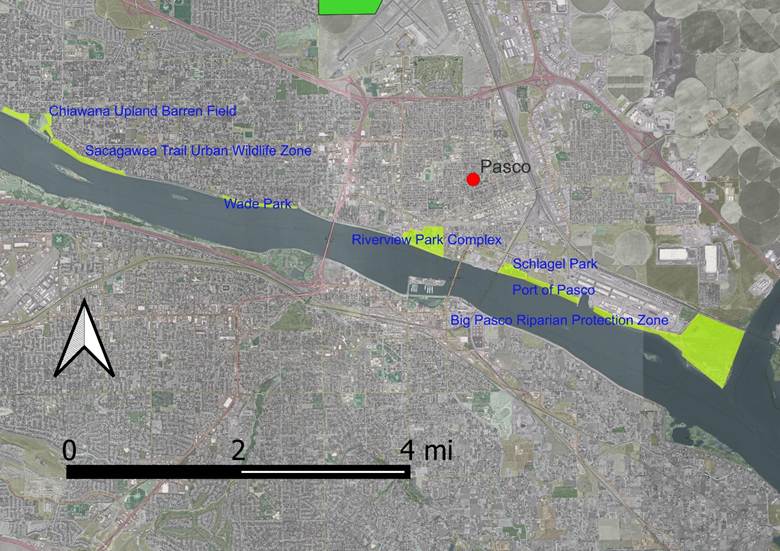
Chiawana Park
Chiawana Park is one of the largest open spaces along the shoreline in the Tri-Cities. Most of the park is designated for “Recreation” in the SMP. The exception is the northwestern most portion of the park which is heavily forested and designated for “Urban-Conservancy”. The primary objective with this excellent example of riparian habitat is to retain the wild nature of the area and prevent vandalization of the flora. Nearby homeowners are of mixed feeling about this area. Some find it attractive and others view it as a nuisance that blocks their view of the river.
There are large tracts of land within Chiawana Park that are undeveloped and one can still find evidence of the asparagus fields that once dominated this region. The middle section of the park between the shaded west and east ends is mostly covered by cheat grass down to and across the bicycle path. There is a narrow section of riparian habitat (dominantly coyote willow) that was until recently mowed down and into the river. Park personnel frequently drive heavy trucks and equipment on the river side of the bike path that compacts the soil preventing any natural growth.
North of the boat ramp and further from the river are similar areas that now harbor cheatgrass and could be potential Shrub-Steppe restoration sites.
There are however complex relationships between local environmental groups, the City, the USACE and the Tribes that are non-functional for both personal and legal reasons. All the regional cities view the USACE as the major problem and have and will again be asking for “reconveyance” through the US Defense Appropriations Act. The cities expect this to reduce bureaucratic delay but it is not clear how environmental concerns will be addressed. Nor is it clear how Washington state entities (Dept. of Ecology, WDFW, etc.) will be involved. Reconveyance is expected to affect all shoreline lands from Burns road to Sacagawea Park.
The Sacagawea Trail Urban Wildlife Area
The SMP designates the land East of the Pasco Boat Basin along the Sacagawea Trail to the #12 dyke for Urban Conservancy. The area is just over 1 mile in length and about 200 feet wide. The objective for this area is to maintain its wild nature and prevent vandalization by local residents desiring a better view and city parks department personnel who will mow anything that grows if not properly supervised.
Wade Park
Is also about 1 mile in length and 200 feet wide. It consists mostly of sod extending down to the water’s edge. It has few other recreational facilities except for the boat ramp on the west end. Shade trees are almost nonexistent. And except for the bicycle path, the park is underutilized and is primarily used for the annual hydroplane boat races and 4th of July fireworks. From an ecological perspective the major issue is the lack of any eutrophicate filtration function that riparian habitat along the shoreline would provide.
Riverview Park Complex
The Riverview Park complex consists of a small park, a large pond, the old and new animal shelters, baseball fields and some undeveloped land. The primary owner is the City of Pasco with some sections along the dyke owned by the USACE. The pond may have been part of the Pasco water treatment facility but is now home to wetlands, associated wildlife and riparian habitat. Protection of the riparian and wetland habitats would be the major priority.
Schlagel Park
Schlage Park is owned by the USACE and presumably leased to the City of Pasco. Its primary use is as a boat ramp and boat slip rental. It has some riparian habitat that could be expanded particularly along the northeast edges.
Port of Pasco
Adjacent to Schlagel Park is the Port of Pasco who actually owns the river shore. The Port has been supportive of habitat restoration and allowed a native plant installation on its west end. The area is also known as Osprey Point and the port should be encouraged to allow large trees to continue to grow and the underbrush to grow wider.
Big Pasco Riparian Protection Zone
Just down stream from the Port of Pasco is the Big Pasco riparian zone which is also owned by the Port of Pasco. It is similar ecological function to the riparian zone at the western Port of Pasco property and provides a significant barrier to pollution of the river from industrial operation including the Big Pasco facility. These two areas along with sections near Sacagawea Park are critical to prevent pollution from industries north of these shorelines. Industrial use is expanding rapidly including Amazon trucking centers and agricultural processing plants. Stormwater runoff and industrial processing waste water are major concerns.
Sacagawea State Park
Both Washington State and the USACE own the land in this region. Most of the actual park areas, including the interpretive center, the playgrounds and swimming beach, are owned by the state and most points north of that by the USACE. These points north are mostly Shrub-Steppe that appears to be in modestly good health. There is a small pond near the northwest corner whose wetland nature might be enhanced. This are might be a good spot for some demonstration project.
Appendix B. Site Maps
The following maps were created with QGIS and have Franklin County Parcel Boundaries, Mid-Columbia Basin Cities, SCBID irrigation channels and wasteways, Google satellite web map and Open Street web Map. The Google and Open Street data are web based but the other GIS data files may be found on my GitHub account at petyrrolls/GIS_Data: public GIS data